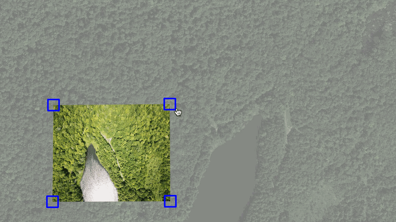
Use Public Lab's open source MapKnitter to upload your own aerial photographs (for example, those from balloon or kite mapping: https://publiclab.org/wiki/balloon-mapping) and combine them into:
Component 1 has been broken out into a new Leaflet plugin, Leaflet.DistortableImage, which allows for client-side, CSS3-based distortion of images over a Leaflet base map.
Component 2 is a Ruby on Rails application which is the core of what you've looked at. It stores images, image corner locations, annotations, map details, and user accounts.
Component 3 is a set of calls to an external application, MapKnitter Exporter, which performs the distortions and geolocations and produces export products like GeoTiff, TMS, JPG, etc. The external exporter service is built in a small Sinatra app at mapknitter-exporter-sinatra using the mapknitter-exporter gem. Requests for exports are sent and progress is tracked using the API.
Installation
Please consider which installation method you prefer. Cloud Installation requires fewer steps and is platform agnostic, but you may value working from your terminal, for familiarity, more.
(Optional): For exporting, you'll need GDAL >=1.7.x (gdal.org) as well as curl and zip-- but these are not needed for much of development unless you're working on the exporting features.
$ sudo apt-get install gdal-bin python-gdal curl libcurl4-openssl-dev libssl-dev zip
==================
RVM
This is for RVM, but the alternative, rbenv, also works (instructions not listed here). Don't install RVM if you already have rbenv!
At this point during the process, you may want to log out and log back in or open a new terminal window. RVM will then properly load in your environment.
Ubuntu users only: you may need to enable Run command as a login shell in Ubuntu's Terminal under Profile Preferences > Title and Command. Then close the terminal and reopen it.
Use RVM to install version 2.4.6 of Ruby:
macOS Big Sur users only: You may encounter a Error running '__rvm_make -j8' compilation error while installing Ruby with RVM. Run export warnflags=-Wno-error=implicit-function-declaration and then retry the installation command below. if you still encounter issues, this thread provides very helpful suggestions.
$ rvm install 2.4.6
==================
Yarn
We use Yarn as our package manager, and it is available through npm.
Install npm:
$ sudo apt-get install npm
Ubuntu users only: you may need to also install the nodejs-legacy package, as due to a naming collision, some versions of Ubuntu already have an unrelated package called node. To do this, run:
$ sudo apt-get install nodejs-legacy
Once npm is installed, you should be able to use it to install Yarn:
You'll need Ruby v2.4.6 (use your local ruby version management system - RVM or rbenv - to install and set up locally).
Fork the repo from https://github.com/publiclab/mapknitter
Clone the forked repo into any fresh, temporary folder with git clone https://github.com/your_username/mapknitter.git
Change your working directory into the root folder you just cloned locally with cd <folder-name>
Add upstream with git remote add upstream https://github.com/publiclab/mapknitter.git
Install gems with bundle install. You may need to run bundle update if you have older gems in your environment.
Copy and configure config/database.yml from config/database.yml.example using a new empty database you've created.
Copy and configure config/config.yml from config/config.yml.example. For now, this is used for adding the Google Maps API Key configurations and a path for logging in when running locally. Both are optional.
Initialize database with bundle exec rails db:setup
Enter ReCaptcha public and private keys in config/initializers/recaptcha.rb (copied from config/initializers/recaptcha.rb.example). To get keys, visit https://www.google.com/recaptcha/admin/create
Install static assets (like external javascript libraries and fonts) with yarn install
Start rails with bundle exec rails s and open http://localhost:3000 in a web browser. For some, just rails s will work; adding bundle exec ensures you're using the version of passenger you just installed with Bundler.
http://youtu.be/iGYGpS8rZMY (it may be slightly out-of-date but gives an helpful overview of the entire installation process.)
Windows Installation
We recommend either working in a virtual environment or on a dual-booted system to avoid dependency issues. In addition, the Unix operating system works smoother with Ruby on Rails. Using a Linux or macOS will not only benefit you now with the Mapknitter project, but will also make your life easier while working on other Ruby projects in the future.
Because MapKnitter uses a remote, OpenID login system that depends on PublicLab.org, it can be hard to log in when running it locally. To get around this, we've created a local login route that requires no password:
You can log in locally at the path http://localhost:3000/local/USERNAME where USERNAME is the login name of a user saved on your database.
For this to work:
You will need to have copied and configured config/config.yml from config/config.yml.example.
The user has to be an existing record. For your convenience, we have added two user accounts in seeds.rb to make their corresponding paths available in development after installation:
For questions related to the use of this software and balloon or kite mapping, the mailing-list page above links to the "grassrootsmapping" discussion group.
Code of Conduct
Please read and abide by our Code of Conduct. Our community aspires to be a respectful place both during online and in-person interactions.
In addition to automatic testing with Travis CI, we have a branch (unstable) that is set to auto-build and deploy to a staging instance. This instance includes a copy of the production database and is intended for experimenting or debugging purposes in a production-like environment. We also have a stable build at https://stable.mapknitter.org/ which builds off of our main branch. Any commits or PRs merged to the main branch will trigger the stable server to rebuild, and you can monitor the progress at https://jenkins.laboratoriopublico.org/
License
MapKnitter is free software: you can redistribute it and/or modify
it under the terms of the GNU General Public License as published by
the Free Software Foundation, either version 3 of the License, or
(at your option) any later version.
MapKnitter is distributed in the hope that it will be useful,
but WITHOUT ANY WARRANTY; without even the implied warranty of
MERCHANTABILITY or FITNESS FOR A PARTICULAR PURPOSE. See the
GNU General Public License for more details.
You should have received a copy of the GNU General Public License
along with MapKnitter. If not, see http://www.gnu.org/licenses/.
MapKnitter in depth
MapKnitter is a free and open source software created and run by Public Lab. MapKnitter is hosted through a donation of server space by Rackspace.
MapKnitter can make maps from any image source, but it particularly lends itself to making maps with balloons and kites. The manual process of making maps with MapKnitter differs greatly from automated aerial imaging systems. In those systems, the imaging is of higher precision and processed with spatial and telemetry data collected along with the imagery, typically at higher altitudes and with consistent image overlap in the flight path sequence.
With MapKnitter, the cartographer dynamically places each image and selects which images to include in the mosaic. However, the approaches are similar in that they use some type of additional information (usually pre-existing imagery of a lower resolution) as a reference, and that they are bound to specific cartographic elements such as map scale and map projection.

 客服电话
客服电话
 APP下载
APP下载

 官方微信
官方微信


请发表评论